Insights
Mapping the Future: Growth with GIS
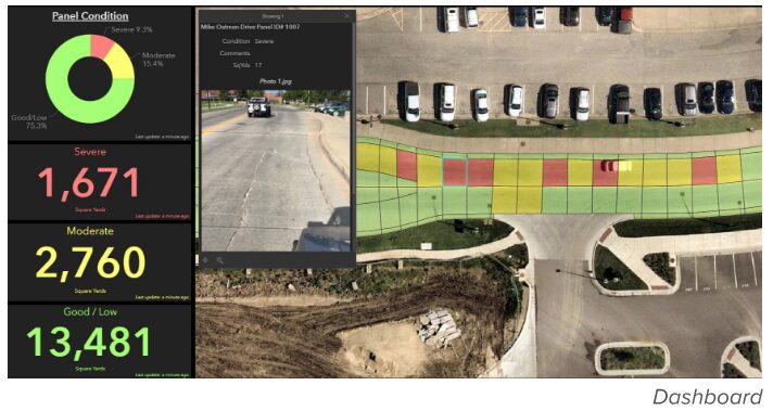
Geographic Information Systems (GIS) are maps that have databases underneath them. They are live documents that render intricate details about geographic space including buildings. For example, an installed water valve would show up on this live map allowing someone to identify the type of valve, when it was installed, and where it is in the system. Anything with a location can be mapped in GIS, and the information can be channeled to mobile devices for immediate access.
 PEC’s GIS specialist, Sheldon Bina, has brought his expertise and skills to our clients for more than 25 years. His continued passion for GIS has only grown as the technology has. As a lifelong leaner, he continues to dive deeper into the world of GIS and what it could offer.
“There’s a lot of training videos I watch to stay up to date on the latest advancements,” Sheldon said. “It’s interesting and fun to learn how technology has evolved and how individuals in the field continue to make breakthroughs through daily use. I am constantly learning more about new capabilities that were not available before.”
Another key benefit of GIS is how quickly and efficiently clients can be served. Sheldon has come to appreciate how GIS can help PEC clients.
“It’s always great to see our clients get excited about [GIS] and learn how they can utilize this technology, how it makes their jobs easier, and how it gives them information that they wouldn’t otherwise have,” he added. “All this information helps them make better decisions and eliminates human error.”
With environmental impact as a consistent thread through PEC projects, Sheldon shared how GIS also plays a role in this effort.
“GIS plays a huge role in sustaining our natural resources. One example is that it can be used to map and track hotspots of water leaks within a water utility system and includes data such as pipe size, material, and age. Visualizing those commonalities within other parts of their system allows for the water utility to be aware of potential problems and being proactive in planning for those replacements.”
Everyone from field engineers to city planners and land developers use this real-time tool. In his experience with GIS, Sheldon believes it has great potential to impact others beyond its usual AEC application.
“I am excited about how GIS will continue to evolve into a tool that even more people will utilize to be efficient and make better informed decisions. The beauty of GIS is that it can be used for anything that has a geographic component, thus it can make an impact for everyone.”